BoM meteorologist Dean Narramore said multiple days of severe thunderstorm warnings are likely. Image: BoM.
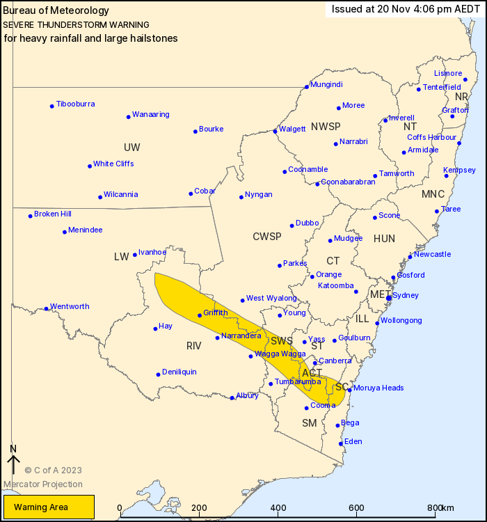
The Bureau of Meteorology has issued a severe thunderstorm warning for heavy, locally intense rainfall and large hailstones this afternoon (20 November).
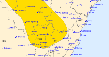
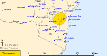
The warning applies to parts of the ACT, South Coast, Southern Tablelands, South West Slopes, Riverina, Snowy Mountains and Central West Slopes and Plains forecast districts.
“A northeasterly airstream will draw moisture into the state, with a deepening inland trough aiding the development of severe thunderstorms in NSW today,” a BoM spokesperson said.
“Severe thunderstorms are likely to produce heavy rainfall that may lead to flash flooding and large hailstones over the next several hours in parts of the South Coast, Southern Tablelands, South West Slopes, Riverina, Snowy Mountains, Australian Capital Territory and Central West Slopes and Plains districts. Locations that may be affected include Cooma, Griffith, Gundagai, Tumut, Junee and Darlington Point.
“Severe thunderstorms are likely to produce heavy, locally intense rainfall that may lead to dangerous and life-threatening flash flooding and large hailstones over the next several hours in parts of the South West Slopes and Riverina districts.”
According to BoM meteorologist Dean Narramore, thunderstorms are expected to hit much of northern and eastern Australia this week.
“We’re likely to see multiple days of severe thunderstorm warnings across large parts of northern and eastern Australia,” he said.
Mr Narramore said the patterns of instability (energy in the atmosphere for when storms do develop) suggest thunderstorms will be hit-and-miss across the country throughout the week.
“One day you’ll be hit. The next day, not so much,” he said.
On Thursday and Friday, there will be large amounts of energy for potential storms.
Mr Narramore said widespread showers and storms are expected across much of NSW this evening, “and that pattern’s going to continue as we move in the coming day”.
Moving into Tuesday, widespread wind and rain are likely again.
“Again, severe thunderstorms with large hail and damaging winds and heavy rain are possible each day,” he said.
The NSW State Emergency Service advises that people should:
- Move your car under cover
- Keep clear of creeks and storm drains
- Don’t walk, ride your bike or drive through floodwater
- If you are trapped by flash flooding, seek refuge in the highest available place and ring 000 if you need rescue
- Be aware that run-off from rainfall in fire-affected areas may behave differently and be more rapid. It may also contain debris such as ash, soil, trees and rocks
- After bushfires, heavy rain and the loss of foliage can make the ground soft and heavy, leading to a greater chance of landslides
- Unplug computers and appliances
- Avoid using the phone during the storm
- Stay indoors away from windows, and keep children and pets indoors as well
- Stay vigilant and monitor conditions. Note that the landscape may have changed following bushfires.
For emergency help in floods and storms, call the SES (NSW and ACT) on 132 500.
Original Article published by Lizzie Waymouth on Riotact.