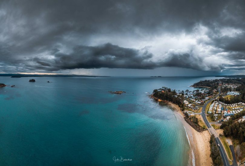
South Coast photographer Josh Burkinshaw captured this image of low-level shelf cloud over Caseys Beach near Batemans Bay. Photo: Josh Burkinshaw.
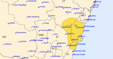
The south-eastern seaboard of NSW between Batemans Bay and Eden is set to receive continued widespread rainfalls with destructive winds and large seas over the coming days.
A trough of low pressure off the coast is deepening into a low-pressure system, with its main centre forming over the Tasman Sea and the secondary centre developing off the southern coast. The low-pressure system is forecast to linger in the region through the week, bringing windy and wet weather as well as large waves to parts of the coast.
Bureau of Meteorology meteorologist Diana Eadie said although the development of a classic east-coast low is looking less likely, the system still has the potential to bring severe weather from Monday onwards.

A rainbow over the paddocks near Braidwood on Monday morning. Photo: Kim Treasure.
“A low in the Tasman Sea will bring wet and windy conditions and large waves to the NSW coast,” Ms Eadie said on Monday (13 July).
“The low is currently located near the south-east coast of NSW and has already brought significant rainfall to the area, heavy snow to the alpine areas and water spouts were observed offshore.
“Heavy falls will continue on the NSW South Coast as the low begins to intensify and the onshore airflow strengthens.
“This includes areas that were severely impacted during the recent bushfire season, making the landscape more vulnerable to landslips and felled trees.”
Ms Eadie also described the system as a dynamic one, meaning that forecasts for specific areas could change as the low-pressure system intensifies.
However, rain will likely be welcomed by many in the area who have not seen significant falls since shortly after the bushfires.
While there are no flood warnings for any of the rivers in the south-east of NSW, there is a strong wind warning for the coast between Batemans and Eden.
There is also a hazardous surf warning for the Batemans and Eden coast, with the surf and swell conditions expected to be hazardous for coastal activities such as rock fishing, boating and swimming.
Waves heights of up to seven metres are forecast off the NSW coast from Tuesday, until the low-pressure system begins to move further out to sea by Friday.
Wind and rain will gradually ease from Wednesday as the low moves further offshore, although large waves will linger into the second half of the week.
Montague Island recorded 75.2 mm during the 24 hours to 9:00 am on Monday, a new July daily rainfall record for the site, with data going back to 1956.
Other totals in the area for the same period included 40 mm at Moruya Heads, 68 mm at Bega, 90 mm at Eden, 85 mm at Wallaga Lake and 65 mm at Merimbula.
Further inland, Nimmitabel picked up 58.2 mm, which is more than a month’s worth of rain for this time of year.
At higher elevations, the last 24 hours produced the best falls of snow so far this season in NSW as moisture-laden air fed into a pool of cold air sitting above the alps.
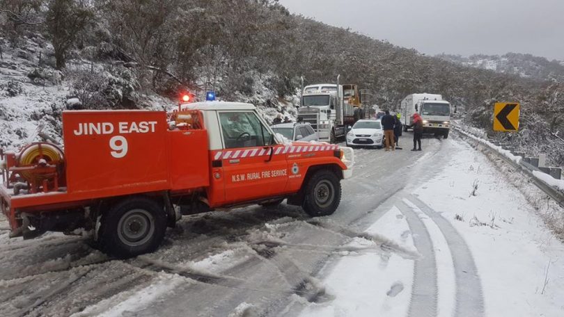
Heavy snow has caused a number of roads to be closed in the Snowy Mountains area. Photo: NSWRFS.
Snow began falling on Sunday and continued throughout the night. By Monday morning, some ski resorts had picked up more than 30 cm of fresh snow (Thredbo and Charlotte Pass), with up to 45 cm at Perisher.
Snow also settled at lower elevations around Jindabyne and Adaminaby, although the snow was considerably wetter that far down the mountains due to higher temperatures. This wet snow is likely to become heavy as it accumulates which may cause tree branches to snap under the weight.