6 June 2021

Moruya Bypass explainer: How was the route chosen and what are the concerns?

| Hannah Sparks
Join the conversation
14
Moruya Bridge and town

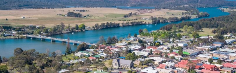
Traffic over the existing bridge in Moruya. Photo: Transport for NSW.

Transport for NSW recently revealed the preferred corridor for the Moruya Bypass and the community is invited to have its say on the proposed route until Monday, 14 June.

While supporters of the bypass have said it will reduce congestion and improve travel times for those driving along the South Coast, there is concern among some of Moruya’s community about the visual and social impact of the project.

What is the preferred route?

The preferred bypass corridor is about eight kilometres in length starting near Shelley Road and running parallel to the east of the existing highway to the Larrys Mountain Road intersection.

From Larrys Mountain Road, the corridor veers further east with a new bridge crossing the floodplain and Moruya River about 2km east of the existing bridge.

South of Moruya River, the corridor continues and crosses over South Head Road to re-join the existing highway.

Moruya bypass corridor

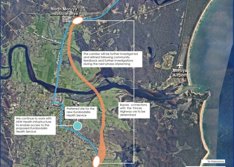
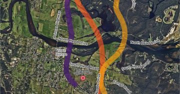
The preferred corridor for the Moruya Bypass (orange) alongside the existing Princes Highway (blue). Photo: Transport for NSW.

Transport for NSW said the preferred corridor will provide connections to the local traffic network at the northern end, near North Moruya Industrial Estate, and southern end, near Mountain View Road.

READ ALSO Time to have your say on the Moruya bypass route

However, the agency won’t know where additional connections will be located until the project moves into the concept design development.

Transport for NSW considered five shortlisted corridors including the preferred 8km orange option, a 7km purple option, 11km blue option, 9km yellow option and 13km green option.

It said it based its decision on assessment of those options against key objectives such as safety, resilience and accessibility, and community consultation with residents, Eurobodalla Shire Council and Moruya Business Chamber.

What are the benefits?

The bypass is aimed at decreasing the travel time for motorists driving through Moruya and catering for the town’s future growth.

Eurobodalla’s population is projected to increase from 37,968 people in 2016 to 40,617 by 2031.

Transport for NSW said the key benefits include safer journeys for everyone including those using the bypass and town centre; reduced congestion and fewer heavy vehicles travelling through the town centre; improved flood resilience of the highway and better access to the proposed Eurobodalla Hospital and Moruya Tafe.

Moruya Bypass supporters

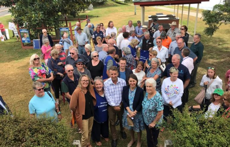
Front, from left: Eurobodalla Shire Council Mayor Liz Innes; Member for Bega Andrew Constance (centre); NSW Premier Gladys Berejiklian (second from right) and supporters at the Moruya Bypass announcement in March 2019. Photo: Alex Rea.

It also said the bypass of Moruya will unlock opportunities to improve the feel of the town centre for the benefit of locals, pedestrians and businesses and complement the appealing, tourist-friendly experience of the town.

Research of the Berrima and Mittagong bypasses by the Bureau of Transport and Communications Economics, found business sales, tourism, and property and land values grew after the bypasses were completed because less traffic through their town centres improved their appeal.

What are the community’s concerns?

The community is worried about the visual impact of the bypass raised across flood-prone paddocks.

It’s also concerned about the level of consultation with landowners within the corridor.

Some affected landholders said waiting to find out when and under what terms they’ll lose their property has impacted their wellbeing.

These landholders also said there had been little to no consultation.

Other community members are also concerned the Government will prioritise funding the bypass over the new Eurobodalla Hospital in Moruya.

What is Transport for NSW’s response to concerns?

In response to concerns about the bypass being built over flood-prone paddocks, Transport for NSW said all shortlisted options required major bridge structures across the floodplain.

It said the bridge height, length and exact location won’t be finalised until the concept design development.

Transport for NSW also said members of its project team attempted to door knock all properties within and near the preferred corridor before the route was announced.

It said members of the project team also met with a number of land and business owners following the announcement to discuss potential impacts and the next steps.

As the features and connections of the bypass corridor are yet to be determined, the full impacts to properties are not yet known.

Transport for NSW said more information will be shared directly with property owners as the design progresses and impacts are confirmed.

It also said compensation for landowners will be guided by the Land Acquisition (Just Terms Compensation) Act.

In terms of the hospital, Transport for NSW said it’s continuing to work with NSW Health Infrastructure as plans for the new hospital progress.

The NSW Government has also purchased the land for the new hospital between Albert Street and the Princes Highway in Moruya, further reinforcing its commitment.

NSW Minister for Transport and Roads and the Member for Bega, Andrew Constance, didn’t respond to a request for comment.

Feedback before 14 June can be provided via Transport for NSW’s survey and by pinning comments to the interactive map.

Join the conversation

14
All Comments
  • All Comments
  • Website Comments
LatestOldest
Annette Hermens6:31 pm 09 May 22

Hurry up! This road is so sorely needed by all in the community as well as our holiday makers. Elevating the road is the only sensible solution with regards to flooding, we only have to look at the 2022 floods in the northern rivers to see what happens when infrastructure is placed on the ground and no regard given to natural circumstances when they occur.

The Orange corridor that has been suggested (and I would like to know by whom and how many chose this one),is far too long. There is no need to include Shelly Road in the Bypass. Agreed, something does have to be done there but this can be achieved without including it in the Bypass.

The best and least destructive route is the purple route. It goes through minimum water areas and is closer to town, closer to the hospital and much cheaper to build. If we want to save our town, i.e. bring tourists in – then the closer route is the best.

The Berry Bypass was done extremely well, homes that were near it – had a sound barrier build and motorists can easily visit Berry if they want to.

The proposed massive structure across our prime flats will not only be an eyesore but will need continuous up keep – re the acid soil, and water run off.

Robyn Broughton6:35 am 11 Jun 21

Enjoyed this edition very much and very informative I always look forward to reading input to learn more of what is going on in the area I live in I love living here on the South Coast a lot of people say We live in Paradise.
I am glad Ian Campbell started off About Reginal and it has grown to what it is today a much looked forward score to learn what is happening in our regeion

Damien Rogers7:28 pm 09 Jun 21

PROBLEMS WITH PROPOSED MORUYA BYPASS ROUTE.

Note, I am for a bypass, just not the current proposed route.

Firstly everyone needs to be aware that the new bridge and highway will be 2km to the east (at the closest point) and the nearest turn off to Moruya from this new road will be 3.2km from the South of town or 3.5 from the North of town.

Why is this a problem?
Studies of bypasses show that the further the highway is moved from the town being bypassed, the bigger the economic impact on the town and its businesses.

Example Study

https://dspace.carthage.edu/bitstream/handle/123456789/6263/MattF.pdf?sequence=1&isAllowed=y

pg.8.

“The results showed that the farther away the traffic is transported from the city, the greater effect that the bypass has on the city.
One place of study is in Yass, Australia. A bypass was built around the town and after a year, researchers studied the area. “48.3% of retail businesses had a decrease in gross annual sales. 14% of jobs were lost.” (Srinivasan et al. 2002). “

So if you look closely at bypasses up and down the coast (that people recognise as successful) you may notice that nearly all have bypasses that merely skirt the edge of town, and have a turn off into the CBD or main street from the bypass.

However the Moruya bypass plan does not appear to look at economic impacts on the town of moving the Highway several kilometres away?

Their main reason given for preferring the Orange route over the purple route is “liveability” claiming a lower impact for the orange option, but this appears to be incorrect.

e.g. The Orange route goes through many clusters of homes, some of which will obviously have to be demolished. One elderly farming couple came to the same public info session and complained that they were not informed that they were affected, or that their home would likely need to be demolished.

Compare this to the alternative Purple route, which is actually the lowest impact route. Coming across the river through tree cover just east of riverside park, not even visible, then through an empty paddock in front of the sewer works (no view lost there) Then through empty wetland paddocks next to the existing highway and golf course (no-one affected there?) then behind trees heading south east behind the big Church block and TAFE and joining back to the old Highway right before the entrance to the new Hospital. Also there can be no future development around the purple route road, because it is all through flood prone lowlands where development is not allowed.

The longest route to the new hospital is actually the Orange route (as the government plan admits) Not only is the Orange bypass much longer, but Ambulances will have to drive an extra 1.6km from the new highway to backtrack to the new hospital.

So the ‘liveability’ impact of the Orange route is much higher than the purple, and the economic impact is likely to be far more severe.

We have to the 14th June to submit a comment on this link.

https://princeshighway.nsw.gov.au/tfnsw/phu/have-your-say-moruya?fbclid=IwAR074XFt-bu3NXHJ58h5yS_pF2nvz6RWwWORfCF94xp848g73l-dRorzwQ4

Allan Chisholm3:38 pm 08 Jun 21

Sooner the better. I like the preferred option

This bypass is an absolute necessity … Over the 26 years I have lived in the area, the traffic through town has increased exponentially. The bypass can’t come quick enough for me. The preferred route makes complete sense and will have the least impact on our community

Simply put it is in the wrong place For decades it was planned to use crown lands from around Percy Davis Road South to East of the granite quarry then follow the crown reserved road from the river until it meets the Congo road then Noads road to the highway at the RMS depot. That is in essence the yellow option. The consultants have admitted the yellow option will be cheaper, quicker and will not divide rural properties affected for at least 3 years and not to build reportedly the longest eyesore bridge in Australia. With compassion and sensible planning the yellow option can be done with minimum destruction of homes, quicker and cheaper and not divide prime agricultural lands.
To place concrete piers,40 meters apart on wet salt affected lands with known acid sulphate soils is foolhardy as in such an environment. The construction and ongoing polluted water runoff off this bridge will threaten the Malabar Lagoon habitat.

The bypass is needed but put it in the right place. Use the crown lands available, do it cheaper and quicker and do it with the least impact on peoples homes and farming operations

Jeff de Jager8:17 am 07 Jun 21

Agree. The option of going “east” makes much more sense than buggering up the extremely valuable productive land on the flats.

Damien Rogers7:35 pm 09 Jun 21

x Councillor Dance should reveal that the more direct purple option goes through his land and closer to his farm house, so of course he would prefer the orange option that is furtherest from his home. However the orange option goes closer to many more homes than the purple, and will obviously require some to be demolished.

No secret it affects me but either option divides 7 rural farms in half. In fact the Purple option will have to be 5 meter elevated bridge from near Shelly road to the southern intersection as does the Orange option. Yes it will take my house out but has to be constructed to allow farms along the route to access the o[d highway.
I am sure though the new homes built on the Braemer Estate and the new proposed development behind the Tafe College are not happy with that option. The Yellow option is by far cheaper and quicker to build and will actually operate as a Bypass should. Why would you build such an eyesore so close to a town set in such a perfect rural setting is beyond me. Hard to comprehend!

They can have the house but not the sheds/yards however need to either do it or go away. People need to get a grip and be prepared to suck it up for the minority of time traffic becomes a problem. Live in the cities and it is a daily occurrence. A better option would be to re-direct the road funds towards the new hospital.

Stop talking and get on with it

$148 million for a new Nelligen Bridge.
How much for a new Bypass?
Only $200 million for a new Eurobodalla hospital.
Something doesn’t add up

Couldn’t have said it better myself!

If it hadn’t been for Dr Holland’s dedication and commitment, I’d doubt we’d have even got 1/2 that amount for the much needed hospital.

Daily Digest

Do you like to know what’s happening around your region? Every day the About Regional team packages up our most popular stories and sends them straight to your inbox for free. Sign-up now for trusted local news that will never be behind a paywall.

By submitting your email address you are agreeing to Region Group's terms and conditions and privacy policy.