6 April 2022

Shortlisted options for Moruya Bypass open for public comment

| Albert McKnight
Join the conversation
23
Moruya Bypass

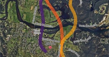
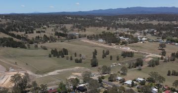
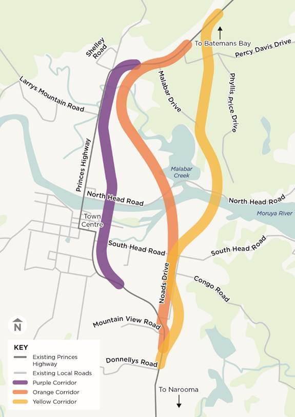
This map shows the three shortlisted corridors for the Moruya Bypass that the government is asking for the community’s thoughts on. Photo: NSW Government.

The community is being asked to have its say on three shortlisted corridors for the Moruya Bypass as the NSW Government considers options for the major project.

The colour-coded corridor options – purple, orange and yellow – all lie east of the existing Princes Highway route and are pictured above.

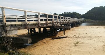
In May 2021, the government announced the orange corridor as its preferred route. This corridor would be about 8km long and start near Shelley Road, the town’s industrial area, in the north, then run south across a new bridge and cross South Head Road to rejoin the Princes Highway.

According to a newly-released Strategic Corridor Workshops Report, the orange corridor was chosen in part because it would improve the flood immunity of the highway, had a low bushfire risk, would minimise impacts on bushland in the east, minimise potential noise impacts and enable the town’s growth.

Overall, the orange corridor outperformed all other options in terms of meeting the project objectives and the wider Princes Highway upgrade roadmap goals, the report says.

However it also says, while a consensus wasn’t reached at a Preferred Corridor Selection Workshop in February 2020, the yellow corridor was preferred by some participants due to its cost. However, this corridor had the highest environmental impact and planning approval risks.

READ ALSO Eurobodalla’s general manager says goodbye after nearly a decade in the role

A Transport for NSW spokesperson said wide-ranging feedback had been received on the preferred corridor option in the previous consultation period and, as a result, Minister for Regional Transport and Roads Sam Farraway decided to reopen consultation this month to ensure the consultation levels met community expectations.

“Community members requested further technical information and access to the Transport for NSW studies which outline the process of identifying the preferred strategic corridor option in more detail,” the spokesperson said.

“Transport for NSW has released detailed information and reopened the consultation on the preferred bypass corridor, giving the community a chance to have their say with additional information.”

Mr Farraway said it was clear there was an appetite to better understand the project and provide more feedback on the preferred corridor.

“The community’s input is crucial to make sure we get this project right, ensure it delivers the best outcome for everyone, and minimises any potential impact on the liveability and natural beauty of Moruya,” he said.

READ ALSO Moruya historian wins heritage award for chronicling quirky stories from town’s past

The public consultation period on the three options opened at the start of April 2022 and will close on 5 June.

“Transport for NSW staff will be out and about across the community meeting with businesses, community groups and offering drop-in briefing sessions,” Mr Farraway said.

The project team will be available to chat at the SAGE Community Market on 12 April and 10 May, as well as the Moruya Country Market on 30 April and 7 May.

Community information sessions on noise, flooding, biodiversity and landscape will be held during May 2022. Dates and an opportunity to register will soon be announced.

Also, Transport for NSW is establishing a flood focus group for the bypass and will invite community representatives to participate in it.

For updates on the process, to have you say, complete surveys and for more information, visit the bypass’s page on the Transport for NSW’s website.

Transport for NSW said the next steps of the project were to undertake additional investigations to develop the concept design and environmental assessment for the bypass.

The bypass is funded in the NSW and Federal Governments’ $1.9 billion Princes Highway upgrade.

Join the conversation

23
All Comments
  • All Comments
  • Website Comments
LatestOldest
Paul Perkins1:02 pm 05 Jul 22

My father wanted to build shelter for woman in mourya. Mourya people said no. My dad wanted to build public houses mourya people said no. He brought land . And look at land now not build my dad s old it back. Your not country town . Your little village that never want change ever ever. Then die.. Your town. People will drive past what happen to mourya. Son they never wanted change so they died.

Paul Perkins12:56 pm 05 Jul 22

With mourya population getting too 10, 000 people. With no jobs on way. More kids are leaving to Sydney get your act together mourya. Now . Or you will be next molong dead town.

Paul Perkins12:53 pm 05 Jul 22

Mourya does not want a bypass or Aldi they want it left as it is . I know I spoke to people . They want a child to get hurt before it happen. They not country they are little village town. Batemansbay had enough of mourya rubbish. If mourya want to go alone let them we . Batemansbay will take councils with them. See how long you last. Like molong .

Melissa Mass3:06 pm 10 Jun 22

The Biodiversity Conservation Act 2016 was introduced to further protect the important biodiversity and habitat features which previous legislation was falling short of doing. The BC Act is very clear in its approach to disturbance of native vegetation with an ‘Avoid, minimise or mitigate’ outcome, set out in order of preference. Each project should therefore ‘avoid’ disturbance to native vegetation, ‘minimise’ disturbance when avoidance can not be achieved and if all else fails then ‘mitigate’ via the offsetting of biodiversity credits is required. The Orange and Yellow corridor routes will impact and disturb native vegetation. This CAN be avoided by selecting the purple corridor as the preferred option for the bypass. The cost of offsetting the disturbance of native vegetation to the areas within the yellow and orange corridor routes are in the 10’s of millions of dollars, a bill which the taxpayer of NSW will be paying. This is an ADDITIONAL COST to the bypass on top of all else including land requisitions, reports, plans and the civil engineering work itself. With the economy struggling to keep its head above water and climate change being a key focus in the most recent federal election it makes logical sense to choose the quickest, cheapest and less environmentally damaging bypass route for Moruya township which is the purple corridor.

Dallis Tanner9:16 pm 10 Apr 22

This diagram is akin to a child’s drawing. How can we possibly make an informed decision with the lack of detailed information regarding arrangements at each end? Please ask for better information on all our community’s behalf.

Margaret Carpenter7:15 pm 10 Apr 22

Yellow – It will allow for future expansion of the town, also the market garden are; be closer to the airport while allowing it expansion too, and appears a straighter route.

It’s a bypass, the further away the better, there will be off ramps into the town, we have too many people with vested interest wanting it in the town. Let’s get on with it and look to the future.

Meyers Roland9:56 am 08 Apr 22

I think the orange option is ok as long as residents from South Head can access bypass north or south.

The purple route is insane for all the reasons mentioned by Jeff. Tyre noise (even from electric vehicles) from 4 to 6 axle trucks on the the yellow & orange routes will be an issue in the still of the evening & mornings, have to suck that one up. The orange route might be an issue for the amphibious aircraft, particularly firefighting aircraft picking up from the river (as demonstrated recently) during emergencies. The yellow route will give a better view of the town as vehicles sweep south on the southwest curve & north on the north east curve, giving travellers the option then to exit on the off ramp at South Head Drive if undecided when joining the bypass at either end. Yes? Will there be an off ramp at South Head Drive? Surely there must be for emergency & all vehicles, particularly exiting to the hospital, residents of South Head & the residential areas of the south, west & southwest of the town, again avoiding the CBD. This would also require a new urban street exit from South Head Drive to the hospital to avoid transiting through established residential areas. To have emergency vehicles travelling south to access the hospital via the southern end of the bypass at Donnelly’s Road, is just ridiculous.

There is no offramp at South Head Rd.

Purple will be an eyesore ruining the northern approach entering the township. It will be a 5 meter high concrete bridge from start to finish across to the Riverside Park, and interfering with Breamer Estate and 20 new houses behind the Taffe college. Far too close to town for a bypass.
The Orange is the longest bridge structure crossing prime agricultural lands impacting marine national parks, a major threat to Malabar Lagoon and the most expensive and difficult option to construct.
The Yellow option has been in place for decades and is the cheapest and quickest to construct. From the Northern exit to the Moruya river it will be on crown lands therefore not interfering with private landholders. However the alignment South of the river needs re alignment so as not to affect homes on that proposed alignment. Simply it needs to include and move East of Congo road to the junction of Noads road then move West through open paddocks to the RMS depot. If that was done no homes on the Southern sector need to be demolished.
On the maps shown here why the Yellow option at the Southern deviates around to end at Donnally’s Road is a mystery and has never been on previous designs and an obvious red herring.
Why we are having another consultation is a mystery when planners of this project so far seem hell bent to not listen to local common sense. They have not contacted landholders previously impacted by extensive studies to keep them in the loop. Is that the way they are going forward with this consultation process?
The Yellow option is the best option. It will be the quickest and cheapest to build however it must be adjusted South of the river to avoid needlessly impacting homes.

I totally agree yellow is the only way to go. The way Keith has explained the southern exit to the highway must surely be looked at with the bridge starting on the north side east of the quarry would have less impact on established housing would not cut the town in half and the cost must surely come into play.

Yellow for me. If we are to bypass we need to do just that. It seems to be the most direct option.

Purple is the best option best value. Still view our pretty village..future electric vehicles will cancel noise problems..won’t stomp over Aboriginal sacred sites …money saved can go to local roads

Jeff de Jager2:59 pm 07 Apr 22

None of the three current bypass route options will bring travellers past the town’s business precinct, its motels or servos. Good signage at both ends will be needed to divert travellers into town whichever route is selected. The Purple will cut the town in half and will need an unsightly concrete (?) elevated roadway over Riverside Park and South Head Road as well as over the flood prone land north and south of South Head Road. The Orange route, and to a lesser extent the Purple, would also be ugly and would bugger up the good farming land north of the river. The Yellow route, while not without some negatives, leaves the town area itself unaffected and should have spectacular views back to town and out to sea; it utilises a tract of Crown Land on the northern side of the river saving cost and acquisitions. Whatever happens will be in place for generations to come so let’s get it right for now and the future. Remember we don’t want the character and amenity of the town to be spoiled by ugly infrastructure but don’t want to ignore the benefits of both reduced heavy traffic in town and the population boost from the new hospital. Yellow’s the goer!

Definitely purple it’s much better value and retains views of our lovely village.. the so called noise problems will be cancelled with electric vehicles..please have some foresight..we will also be not be stomping all over our aboriginal sacred sites it’s a nobrainer !,

Julie Brailey1:03 pm 07 Apr 22

I honk the yellow would be first choice then orange 2ndchoice. Both are deviated far enough from the highway which always gets congested. People will still get off to visit moruya like they do now at Berry. Th fact is that I never go to moruya in the holidays as it is too congested but it will be more inviting to go to moruya in holiday times if you just have to get off the bypass. Both routes are safer for the new hospital also. More noise will be heard from the purple route.

Jan Williamson12:59 pm 07 Apr 22

My choice is the orange route. It appears to have less impact on what is already there and is not too far out that people will still come into Moruya. This is where I thought it was going originally…a good choice.

Brian gillis12:38 pm 07 Apr 22

Orange corridor with an exit to the new hospital

Genny Herbert6:45 am 08 Apr 22

Absolutely needs to be near the new hospital.

The Orange route seems to be the most obvious choice. Minimising the risk of flooding, least environmental impact are two very big wins. It also has fewer curves and bends. Plus it clearly by-passes Moruya rather than skirting around it. I like Orange and for what little my opinion matters that would be my preferred option.

Orange route for me … lower environmental impact and lower impact on Moruya town enabling community friendly development

Robert Boyle9:37 am 07 Apr 22

I agree, that the orange corridor is the best option. Robert Boyle Tuross Head.

Daily Digest

Do you like to know what’s happening around your region? Every day the About Regional team packages up our most popular stories and sends them straight to your inbox for free. Sign-up now for trusted local news that will never be behind a paywall.

By submitting your email address you are agreeing to Region Group's terms and conditions and privacy policy.