A Bell LongRanger helicopter crashed at Kiandra Flats, killing the two people onboard, on 3 April. Photo: ATSB.
The preliminary report into what happened before a helicopter crashed in Kosciuszko National Park at Kiandra Flats has been released by the Australian Transport Safety Bureau (ATSB).
The Bell LongRanger helicopter dropped from a height of 7400 feet above sea level on 3 April 2022, killing the pilot and passenger onboard.
The ATSB report outlined the sequence of events leading up to the crash:
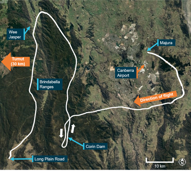
Earlier in the day (3 April) the helicopter left Majura, north of Canberra Airport, as part of seven helicopters on a flying tour. All the helicopters were following a common itinerary but operated independently of each other.
The six other helicopters landed on a property near Wee Jasper as the weather deteriorated, while the Bell LongRanger continued further south before landing alongside Long Plain Road in the Brindabella region.
ATSB director transport safety Stuart Macleod said when the LongRanger didn’t arrive in Wee Jasper, the other pilots contacted authorities and a search was launched.
“With the help of a passing motorist, the pilot of the LongRanger was able to reach mobile reception and contact other members of the tour group, and the search was called off,” he said.
Bell LongRanger helicopter’s flight path from Majura to Long Plain Road. Photo: ATSB.
Recorded flight data showed the LongRanger took off from Long Plain Road almost three-and-a-half hours later at 2:53 pm.
“Police officers dispatched to locate the helicopter as part of the earlier search arrived at the site just after it took off, and observed the helicopter depart to the south at low level, in overcast conditions with low cloud and light rain,” Mr Macleod said.
The forecast for the area at the time of this second flight showed broken cloud between 2500 ft and 10,000 ft above sea level.
Tracking data showed the helicopter continued at below 500 ft above ground level.
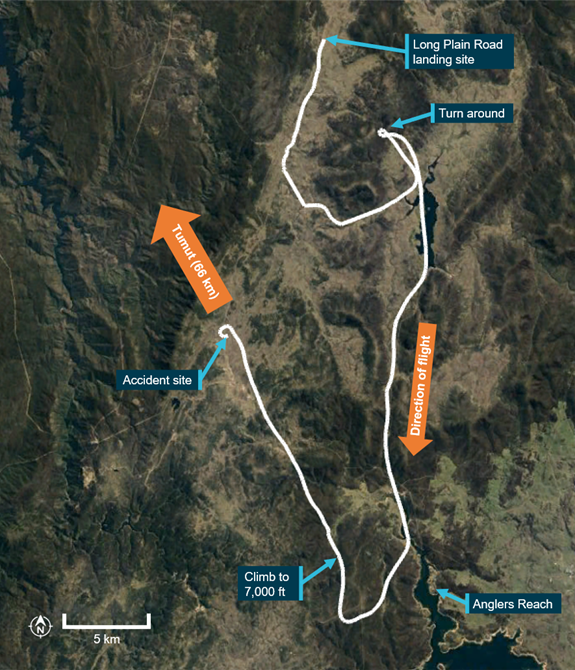
“About 10 minutes into this second flight, the pilot turned north-west and took up a track towards Tumut, which they had indicated to the tour group as their intended refuelling destination,” Mr Macleod said.
“They then encountered higher terrain and turned around to head southward, again following lower lying terrain for another 10 minutes, before reaching Anglers Reach, at which point they turned back on a track towards Tumut.”
Tracking data then showed the LongRanger began ascending and descending at various intervals.
Mr Macleod said at first the helicopter climbed to 7000 ft above sea level (about 2500 ft above ground level) and continued for about six minutes before it descended to 6800 ft, but almost immediately began climbing again.
“After climbing to 7400 ft, the helicopter commenced the steep turn, its ground speed increased to 134 kt, and its descent rate exceeded 3800 ft per minute,” he said.
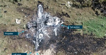
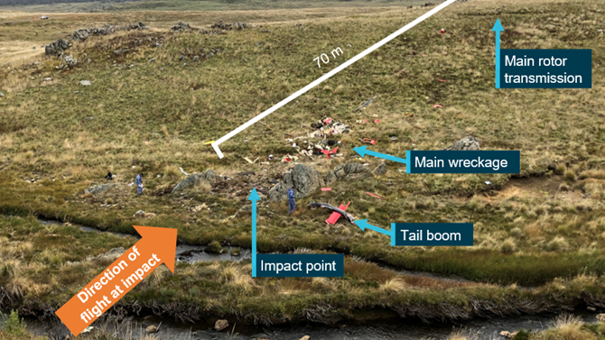
The helicopter crashed at 3:26 pm in an area of tussock grass and bare protruding rock in Kosciuszko National Park.
The final flight path by the Bell LongRanger helicopter. Photo: ATSB.
When the LongRanger didn’t meet up with its group the next day at the planned site at Mangalore, Victoria, a second search was launched. Poor weather prevented an airborne search, and the ground team found the wreckage that evening (4 April).
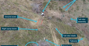
The ATSB’s subsequent examination of the site showed power was present for the helicopter’s engine at the time of impact, and there was no evidence of an in-flight break-up or a pre-existing defect with the drive train or flight controls.
Most of the wreckage was located within eight metres of the impact, but the main transmission, mounts and supporting airframe structure were strewn a further 70 metres up a hill.
“As the investigation progresses, the ATSB will further review and analyse pilot and maintenance records, recovered wreckage components, the flight tracking data, witness information and meteorological data,” Mr Macleod said.
Detailed analysis and findings would be released in the final report at the end of the investigation.
“However, should a critical safety issue be identified at any time as the investigation progresses, the ATSB will immediately notify relevant parties so appropriate and timely safety action can be taken,” Mr Macleod said.
Original Article published by Claire Fenwicke on Riotact.