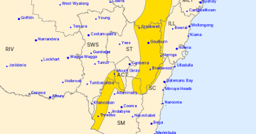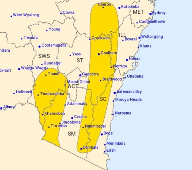
A severe weather warning for heavy rainfall and damaging winds has been issued for parts of southern NSW. Image: BoM.
A severe weather warning has been issued covering large parts of southern NSW and the ACT, with predictions of up to 100 millimetres falling across the region by the end of the week.
The bulk of the heavy rain’s predicted for Thursday (4 August), with damaging wind gusts also on the cards.
It results from a complex low-pressure system moving across the Great Australian Bight, with an associated trough and cold front whipping up winds and increasing the chances for lots of rain. This front will continue to move east and offshore early Friday morning.
Weatherzone meteorologist Ben Domensino said the system heading our way had already given Western Australia a “walloping”.
“The front reached WA on Monday and caused damaging to destructive wind gusts during Monday into Tuesday morning, with some exposed areas in the state’s southwest enduring their strongest gusts in around a decade,” he said.
“Unfortunately, a deep low-pressure system passing to the south of Australia will cause more powerful winds over WA, SA, VIC and TAS on Wednesday and Thursday. Once again, damaging wind gusts are likely in multiple states on these two days as the low gradually moves from west to east.
“This is the type of weather event that we only expect to see around once per year in southern Australia, so it will be important to keep up to date with the latest warnings during the next few days.”
From early Thursday morning, heavy rainfall with the potential to cause flash flooding was forecast to develop across the Snowy Mountains and the South West Slopes.
Six-hourly totals between 45 and 60 millimetres were possible, which could also fall over shorter timeframes given thunderstorms were predicted for overnight.
Bureau of Meteorology senior forecaster Jake Phillips said the heaviest falls would be seen on the western side of the Great Dividing Range, but that didn’t mean other areas wouldn’t see impressive totals either.
“Tumut is likely to see a fair bit – they’re most likely to get 60 to 100 millimetres,” he said.
“The peaks of the Brindabellas could potentially see even more than that … while as you move towards the coast, the falls drop off significantly. For example, Braidwood could expect 20 to 40 millimetres, which isn’t the downpour we’re expecting elsewhere but still a decent drop, and it’s a similar story for Cooma.”
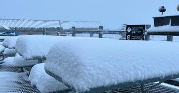
This weather system could spell bad news for the snow resorts, as warmer north to north-westerly winds meant the wet weather was more likely to fall as rain than snow.
“We could see as much as 180 millimetres around the Alpine peaks,” Mr Phillips said.
“For example, at Thredbo Top Station, it would normally be in the negative temperatures, but it’s been sitting at 2 degrees, so anything that falls there will most likely be sleety rain.
“This could melt and wash away a lot of snow that’s accumulated there.”
Minor to moderate flooding was possible for the Castlereagh, Bell, Macquarie, Belubula and Queanbeyan rivers, with moderate to major flooding possible along the Tumut and Murrumbidgee rivers from Thursday.
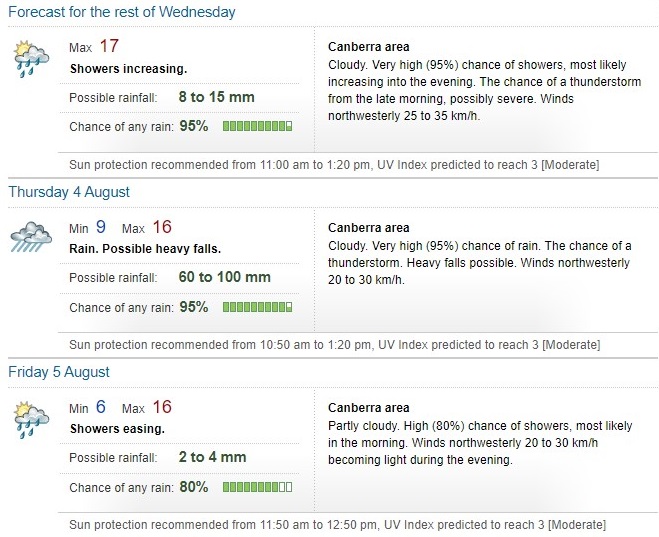
Rainfall totals up to 100 mm are possible for parts of Canberra on Thursday. Image: BoM.
Damaging wind gusts peaking at around 90 km/h were possible over the ranges to the west of Canberra and the eastern Great Dividing Range from Bombala to south of Crookwell. This would extend north to around Oberon during Thursday morning.
Damaging winds averaging 80 to 90 km/h with peak gusts above 125 km/h were likely to continue for Alpine areas above 1,900 metres.
Mr Phillips said potential storms made predicting exact winds difficult.
“Another factor that throws in a wild card is the risk of thunderstorms today and tomorrow, which could throw out strong wind gusts as well,” he said.
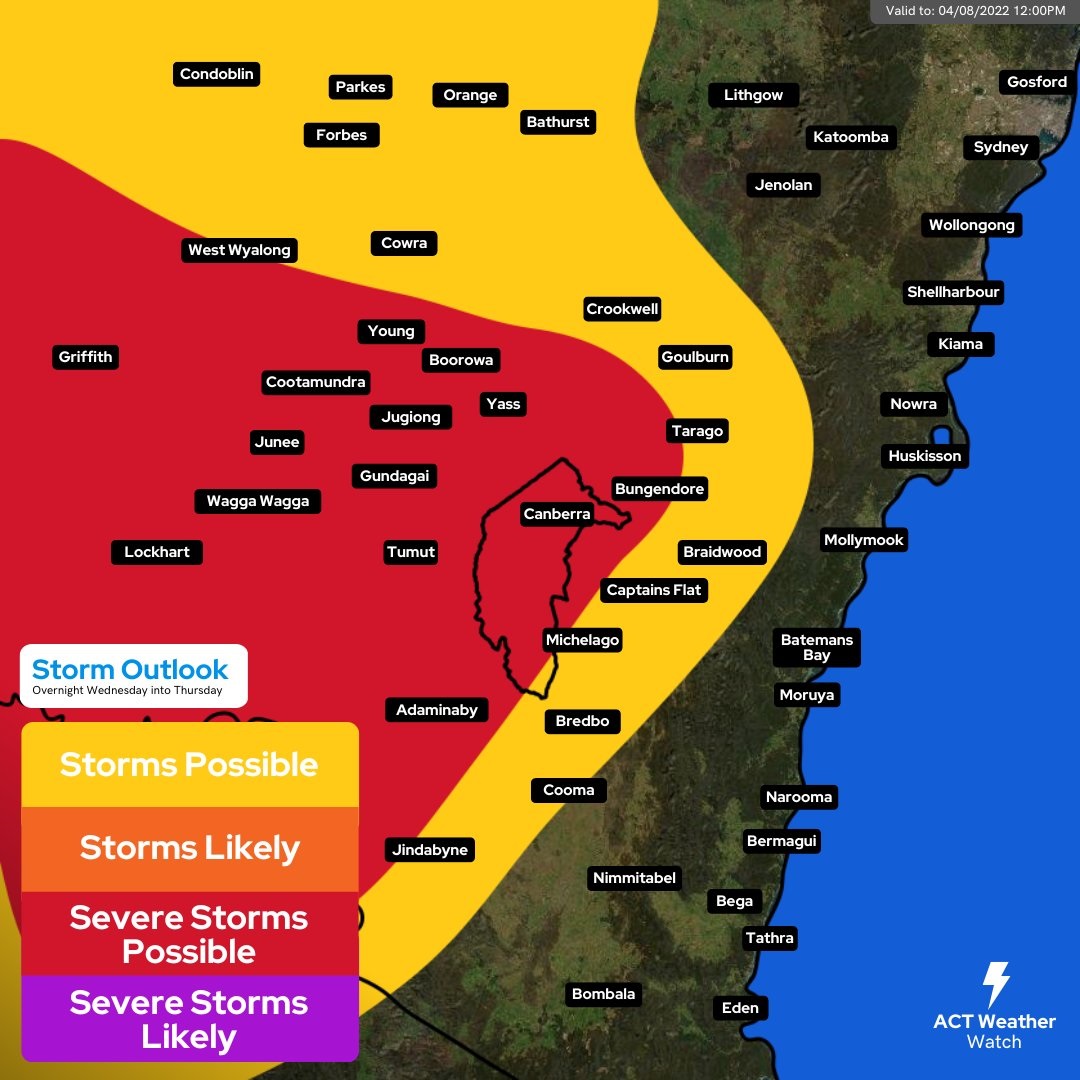
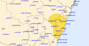
Storm Outlook for 3 August. Image: @actweatherwatch.
The Queanbeyan SES unit warned people to prepare their homes now.
“Minor flooding is possible with 50 to 70 mm of rain forecast for the Queanbeyan area on Thursday with winds of up to 50 km/h,” it said.
“Clean your gutters, tie down loose items such as trampolines and garden furniture and, if practicable, trim overhanging branches.
“Avoid the rivers during heavy downpours as flash flooding is likely to occur.”
A marine wind warning has been issued for the Batemans and Eden Coasts for Wednesday, while the warning extended for the Batemans Coast into Thursday. A strong wind warning was currently in place for the Eden Coast for Thursday.
For emergency help in floods and storms, the SES can be reached on 132 500.
Original Article published by Claire Fenwicke on Riotact.