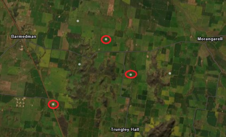
Three earthquakes were recorded near the south-west NSW town of Barmedman during December. Image: Geoscience Australia.
If residents of Barmedman were feeling a bit wobbly during the festive season, they can blame a series of earthquakes within a loud cooee of each other between 14 and 24 December.
The trio of trembles started with a magnitude-2.6 earthquake at 11:28 pm on 14 December, its epicentre narrowed down to a Trungley Hall Road property about 20 kilometres south-east of Barmedman.
The depth of that earthquake – according to Geoscience Australia – was six kilometres and its resulting seismic activity was recorded 343 km west at Cobar, 333 km south at Echuca, 264 km east at Jindabyne, and north-east near the Sydney suburb of North Richmond.
Best of all, it seemed to generate a bit of activity at Geoscience Australia’s seismic station at Parliament House in Canberra on the same day ACT Senator David Pocock urged the government to redouble its efforts to ensure safe passage out of Israel to Australian visa and passport holders.
Two days later – on 16 December – the epicentre of a second earthquake with a magnitude of 2.7 was recorded at 12:32 pm in a paddock near the Graincorp silos at Reefton, about 11 km south of Barmedman.
The depth of that earthquake was five kilometres below the earth’s surface but seismic activity was recorded as far afield as Yappala Station, 899 km away in South Australia; various stations around the Melbourne metropolitan region; north-west in Cobar and Dubbo, Canberra; and trickled up the South Coast to the NSW Central Coast.
And finally, at 5 pm on 24 December as people were scurrying around doing their final shop, earthquake No. 3 – magnitude 2.3 – gave the beers residents of West’s Road, 16 km east of Barmedman, were likely downing at that time a bit of a shake.
Ten kilometres below the surface, seismic wave activity was recorded at Griffith and Cobar stations to the west and north-west, but most stations around the ACT, Snowy Tablelands, South Coast, Southern Tablelands and Wollongong region also registered activity.
Geoscience Australia senior seismologist Hadi Ghasemi said the earthquakes would have been experienced by residents as minor shaking or sounds, like thunder or a loud bang, as the waves reached the earth’s surface, continuing as sound waves.
He said it was not uncommon for earthquakes to occur within days of each other in one region, with many too weak to be felt.
“So, just in the past 20 years, in the 200 km radius of these events we have registered more than 600 events – and 40 of those actually had a magnitude larger than three,” he said. “So earthquake activity in that region is more active than what people think, but they are fairly small to moderate-type earthquakes.”
Historically, the Southern Tablelands towns of Gunning, Yass and Dalton have recorded earthquakes of a higher magnitude, one at 5.5 in Yass in 1886.
In 1934, the year before the Richter scale became the international measure of magnitude, Gunning was at the centre of a 5.6-magnitude earthquake, leaving buildings damaged in that small settlement and in Canberra, some 31 crow miles away.
Then in 1949, a 5.5-magnitude quake with its epicentre between Gunning and Dalton was also felt in Canberra, leaving damaged and cracked buildings in its wake.
To put things in perspective, the state’s largest earthquake – recorded at a 5.6 magnitude – occurred in Newcastle in December 1989, killing 13 people, hospitalising 160 and causing an estimated $4 billion worth of damage to buildings.
Australia’s largest recorded earthquake occurred a year earlier, on 22 January, 1988, at Tennant Creek, in the Northern Territory.
There, damage costs equalled $2.5 million after consecutive earthquakes, the largest at a magnitude of 6.6.
The largest to occur recently and locally was a magnitude-four earthquake near Boorowa in November 2022.
Mr Ghasemi said residents who experienced seismic activity could submit a felt report on what they observed.


