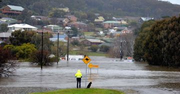
Road closed due to flooding in Moruya. Photo: Karyn Starmer.
Up to 1000 properties in Moruya could be flooded in the most extreme scenario assessed in the draft Moruya Floodplain Risk Management Plan (FRMP). Isolation of communities due to flooded roads affecting evacuation and access for emergency services is another key risk.
The Moruya FRMP recommends 18 actions to minimise the impact of floods and reducing losses. The actions range from minimal cost items such as community education to raising key roads, potentially costing up to $190 million, and voluntary house purchases, potentially costing up to $100 million.
It does not recommend the construction of levees. Nor does it recommend the environmental approach of a managed retreat from flood-prone areas.
It examines different flood scenarios called ‘annual exceedance probability’ (AEP). A two per cent AEP flood has a two per cent or one in 50 chance of being reached or exceeded in a given year. A five per cent AEP flood has a five per cent or one in 20 chance of being reached or exceeded in any given year.
The study by Sydney-based Rhelm, found if there was a five per cent AEP event, 69 buildings in the study area would likely experience over-floor flooding. If it was a two per cent AEP, 255 buildings would be impacted. Up to 1003 buildings would be impacted in a probable maximum flood event.
NSW councils are required to prepare FRMPs. Underlying the FRMP and accompanying the Moruya Floodplain Risk Management Study (FRMS) is a comprehensive technical investigation, the Moruya Flood Study.
Moruya’s largest flood in 1925 exceeded a one per cent AEP event. All seven floods with peak levels of more than four metres at Moruya Bridge happened before 1940.

In August 2020 Moruya was on floodwatch with creeks and rivers up to moderate flooding levels. Photo: Karyn Starmer.
Since then no floods have exceeded the five per cent AEP level, around 3.9 metres. In the past 30 years, none surpassed 2.5 metres, around a 20 per cent AEP level. The current community therefore has limited experience of major flooding.
The study area is traversed by the Moruya/Deua River with an upstream catchment area of more than 1400 square kilometres. Most of the catchment is undeveloped, with small rural areas in some portions of the catchment and more urbanised areas around the Moruya township, towards the centre of the study area.
There are three broad categories of flood risk management.
Flood modification measures, such as levees, aim to prevent, avoid or reduce the likelihood of flooding in the catchment. None are included in the Moruya FMRP.
Property modification measures aim to reduce the consequences of flood risks such as modifying existing properties or imposing controls on future development and infrastructure so there can be ongoing development and use of the floodplain.
The third category is emergency response modification measures that reduce the consequences of floods by changing people’s behaviour during floods. These include increasing warning times so the community and emergency services can better prepare and respond, sound planning for smooth evacuations, and preparing people through community education. Actions could include raising streets.
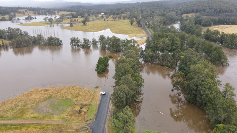
The flooded Kiora Bridge, near Moruya. Photo: Keith Doran, Facebook.
Four of the top five priority actions are emergency response modifications. Those four have a combined indicative cost of $20,000 to $100,000. Cost and responsibility is potentially shared between Eurobodalla Shire Council, NSW State Emergency Services and the Bureau of Meteorology.
The other high priority action recommended is for land use planning updates by council, with an estimated cost of $10,000 to $50,000. Those five top priorities have been assigned a short timeframe.
There are 11 actions classified as medium priority, most falling into the emergency response modification category. The lower cost ones in that category include flood warning signs and depth markers, updating emergency response documentation, additional evacuation centres and collecting data after floods.
The more expensive measures include raising South Head Road at an estimated cost of $50-100 million and raising the Princes Highway in the northern area of the floodplain, costing $10-50 million. The plan also recommends raising Albert Street, Murray Street and Dwyers Creek Road, each with a cost of $5-10 million.
The other two medium priority actions are property modification measures, namely voluntary house purchases of between $50 million and $100 million and property flood risk education with a much smaller price tag of $10,000 to $50,000. The study identified 65 properties council could purchase to reduce risk to life.
The two low priority recommendations are to raise the Princes Highway in the Moruya CBD area, estimated to cost $5 to 10 million and a $200,000 feasibility study into raising the CBD landform.
One of the study’s conclusions is effective implementation of development controls will be key to reducing damage and risk to life.
The FRMP, FRMS and underlying Moruya Flood Study are on public exhibition for comment. Submissions close at 4:30 pm on 10 June.